
(External link)
Raumkarte
- Release Notes
- What is “Raumkarte”?
- Table of Specifications
- List of Raumkarte Products
- Terms and Conditions of Use
Release Notes
English versions are in preparation.
- Version 2025 Release Notes (August 1, 2025)
- Version 2024 Release Notes (August 1, 2024)
- Version 2023 Release Notes (August 1, 2023)
- Version 2022 Release Notes (August 1, 2022)
- Version 2021 Release Notes (August 1, 2021)
- Version 2020 Release Notes (August 1, 2020)
- Version 2019 Release Notes (August 1, 2019)
- Version 2018 Release Notes (August 1, 2018)
- Version 2017 Release Notes (August 1, 2017)
- Version 2016 Release Notes (August 1, 2016)
- Version 2015 Release Notes (August 3, 2015)
- Version 2015 Prerelease Notes (April 1, 2015)
What is “Raumkarte”?
Raumkarte is a worldwide geospatial database constructed on the basis of the coastlines with an accuracy corresponding to a scale of about 1/700,000 - 1/500,000. Our own investigation has made it specialized for use on GIS.
To place an order or ask a question
Table of Specifications
| File format |
Vector data: ESRI File Geodatabase ESRI Shapefile |
|---|---|
|
Raster data: ESRI File Geodatabase Note: Basically provided in the Web Mercator projection. Transformation into another projection is available at an extra charge. | |
| File size | Approx. 3 GB (Worldwide) |
| Data range | Seamless through the world |
| Data accuracy | Corresponding to a scale of 1/500,000 at the maximum |
| Projection Spheroid | Latitude / Longitude Projection (decimal double precision) WGS84 |
| Data (layer) classes | 20 categories, approx. 300 layers |
| Display scales | 10 ranks |
List of Raumkarte Products
Topographic Maps (Vector data)
Comprising about 330 layers (20 categories) with point, line, and/or polygon data showing natural and artificial features, e.g. rivers, mountains, political areas (i.e., countries, local administrative units, and others), parks, roads, railways. 10 zoom levels are supported (approx. 1/24,000,000 – 1/500,000).
| No. | Category name | Contents | Data type | ||
|---|---|---|---|---|---|
| Line | Point | [Polygon] | |||
| 1 | Linear Hydrographic | Perennial and intermittent stream, canal, aqueduct, Intracoastal Waterway, rapid, stream distributary, etc. |  | | |
| 2 | Areal Hydrographic | Ocean, sea, gulf and bay, strait, mouth of river, estuary, lake, reservoir, land ice and glacier, ice shelf, swamp and marsh, mangrove, etc. |  | | |
| 3 | Hydrographic | Perennial and intermittent stream (1/500,000) | | | |
| 4 | Seabed | Basin, trench, seamount(s), ridge, bank, reef, etc. | | | |
| 6 | Landform | Continent, island(s), isthmus, cape, peninsula, mountain range, plateau, basins, plains, land area (of island), atoll, desert, forest, etc. | | | |
| 8 | Parks and Recreation | National park, state park, historic site, reserve and preserve, indigenous reservation, etc. | | | |
| 9 | City | 1st-4th order capital, 1st order future capital, town, urban area, diplomatic missions, oversea office of JETRO and JICA, Chinatown | | | |
| 10 | Cultural | Museum, sports facility, religious facility, scientific station, castle, ruin, wall, historic region, historic site (Japan), etc. | | | |
| 17 | Political Areas | Independent and not independent 1st order political area, 2nd-6th order political area, other subordinate political area | | | |
| 18 | Administrative Areas | Country and region polygon data | | | |
| 19 | Military Areas | Army, navy, marine corps and air force installation (of 94 countries including the US and Japan) | | | |
| 20 | Geographical Reference Line | Equator, Dateline, Tropics, Arctic, Antarctic, coastlines (1/500,000), grid mesh (01, 05, 10, 15, 30, 90 degree(s)) | | | |
To place an order or ask a question
Topographic Maps (Raster data)
Image data to represent Earth altimetry (shade and gradient tints) and bathymetry (gradient tints).
Elevation grid mesh / shaded relief image (1km square)
Elevation grid mesh / shaded relief image (35m square)
Bathymetric grid mesh (500m square)
| Display example in a scale of approx. 1/900,000 (upper) and approx. 1/500,000 (lower) |
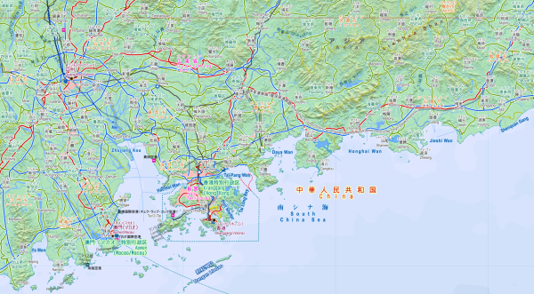 |
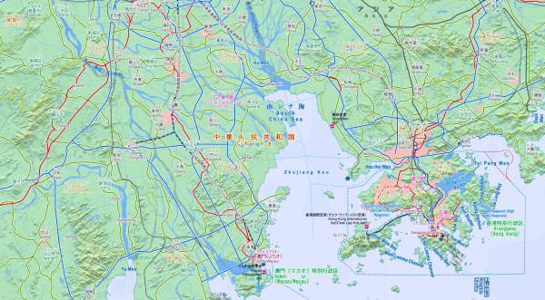 |
To place an order or ask a question
Thematic Maps (Vector data)
Geospatial databases of many topics and themes including the time zone, countries and regions risk, various statistic data by country
・ Time zone (1/500,000)
・ UNESCO World Heritage
・ Countries and regions risk (based upon the Overseas Safety Information by the Ministry of Foreign Affairs of Japan, 1/500,000)
・ Countries risk and threat from terrorism (based upon the Foreign Travel Advice by the Foreign and Commonwealth Office of the UK)
・ Japan’s territorial sea and EEZ (based upon the charts issued by the Japan Coast Guard, 1/200,000)
・ Nuclear weapons tests and nuclear reactors
・ Terrorism incidents after WWII
・ Distribution of religion, language, races, vegetation, terrestrial and aquatic biomes, etc.
・ Köppen climate classification
・ National unemployment rate, suicide rate, total fertility rate, etc.
And more
To place an order or ask a question
Geospatial Database Construction Service
(Custom-made Thematic Mapping)
Additionally to the ready-made thematic maps data listed above, we consult sources and construct geospatial databases or map data of other topics or themes in response to your order, for instance, countries and regions’ area, population (of citizens, foreigners, aged or others), currency, self-sufficiency (in food, energy or others), diffusion (of internet, smart phone or others), etc.
Utilizing your own data (e.g. your company’s branch offices in the world) is available as well.
To place an order or ask a question
City Maps (1/25,000 Raster data)
File format: Tagged Image File Format (TIFF), world files connected
Corresponding to a scale of 1/25,000 (ver. 2011)
Available cities: New York, Los Angeles, San Francisco, London, Rome, Milan, Old Delhi & Indira Gandhi, Mumbai & Santa Cruz, Sydney, Melbourne, Vienna, Toronto, Seoul, Busan, Singapore, Madrid, Barcelona, Bangkok, Taipei & Taoyuan, Beijing, Shanghai, Berlin, Munich, Paris, etc.
Note: City maps (1/25,000) are products of CHIRI Geographic Information Service Co., Ltd. and the original copyrights of those belong to the said company. Users must give appropriate credit in any reasonable manner to print or indicate.
| Bali (Indonesia) | Sydney (Australia) |
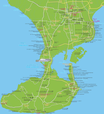 |
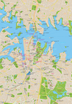 |
To place an order or ask a question
City Maps (1/50,000 Vector / Raster data)
Corresponding to a scale of 1/50,000 (ver. 2008)
Available cities: Tokyo, Osaka, Pyongyang, Beijing, Shanghai, Hong Kong, Jakarta, Katmandu, Delhi, Islamabad, Karachi, Teheran, Abu Dhabi, Amman, Jerusalem, Díli, Washington D.C., Paris, Kiev, Sarajevo, Bucharest, Port au Prince, Cape Town, Nanjing, St. Petersburg, Sydney, Helsinki, Baku, Lisbon, Istanbul, etc.
To place an order or ask a question
Terms and Conditions of Use
Unless otherwise noted, the original copyrights of the data including the Japanese spelling of place and feature names belong to GeoCatalog Inc. Users must give appropriate credit in any reasonable manner to print or indicate ( e.g. Portions Copyright © 2026 GeoCatalog Inc.).
The price system basically comprises the guarantee and the annual royalty. Please feel free to ask for a price quote.
Regional data extraction is available. Please feel free to ask for more information.
If you find out defects in the information of our products, please let us know and we will cordially examine how to cope with that. Regarding matters of opinion, however, we will not necessarily accept customer complaints.